

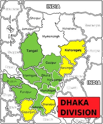
Dhaka Division is an administrative division in Bangladesh. Dhaka is Bangladesh’s capital city and the largest city in the country. It comes among the 10 most populous cities in the world. The Division, as constituted prior to 2015, covered an area of 31,051 km and had a population of 47,424,418 at the 2011 Census. However, following the separation of the new Mymensingh Division in 2015, the area has been reduced to 20,508.8 km2 with a population at the 2011 Census of 36,433,505.
Dhaka Division is bounded by Mymensingh Division to the north, Barisal Division to the south, Chittagong Division to the east and south-east, Sylhet Division to the north-east, Rangpur Division to the north-west, and Rajshahi Division to the west and Khulna Divisions to the south-west.Dhaka Division consisted before 2015 of four city corporations, 17 districts, 123 upazilas and 1,248 union parishads. However, four of the most northerly of the 17 districts were removed in 2015 to create the new Mymensingh Division, and another five districts (those situated to the south of the Ganges/Padma River) are in the process of being removed to create a new Faridpur Division. Now, the total district in the Dhaka division is 13th.
Dhaka District
Dhaka District is a district in central Bangladesh and is the densest district in the nation. It is a part of the Dhaka Division. Dhaka, the capital of Bangladesh, is located in the southeastern part of the district. While Dhaka (city corporation) occupies only about a fifth of the area of Dhaka district, it is the economic, political and cultural centre of the district and the country as a whole. Dhaka District consists of Dhaka, Keraniganj, Nababganj, Dohar, Savar and Dhamrai upazila.
The district shares borders with Gazipur and Tangail to the north, Munshiganj and Rajbari to the south, Narayanganj to the east and Manikganj to the west. The main rivers flowing through this district are Padma, Kaliganga, Dhaleshwari, Ichamati, Shitalakshya, Buriganga and numerous smaller rivers, including Bangshi, Turag, Balu, Elamjani, Alam, Bherujkha, Ramkrishnadi, Elisamari, Tulsikhali. Major lakes (“beels”) include Belai, Saldaher, Labandaher, Churain, Damsharan and Kiranjir Beel. The annual average temperature of the district is a maximum of 41.1°C and a minimum of 11.5°C; the yearly average rainfall is 1931mm.
Gazipur District
Gazipur District is in central Bangladesh and is part of the Dhaka Division. It has an area of 1741.53 km² and a population of 5,263,474 people as of 2022. The district is home to the Bishwa Ijtema, the second-largest annual Muslim gathering in the world with over 5 million attendees. Gazipur is also home to numerous universities and colleges, the Bangabandhu Sheikh Mujib Safari Park, Bhawal National Park, and the country’s only business park – the Bangabandhu Hi-Tech City.
The district shares borders with Munshiganj and Rajbari to the south, Narayanganj to the east, Manikganj to the west, and Tangail and Dhaka to the north. The main rivers flowing through this district are the Shitalakshya, Turag, Balu, Elamjani, Alam, Bherujkha, Ramkrishnadi, Elisamari, and Tulsikhali. Major lakes (“beels”) include Belai, Saldaher, Labandaher, Churain, Damsharan, and Kiranjir Beel. The annual average temperature of the district is a maximum of 41.1°C and a minimum of 11.5°C; the yearly average rainfall is 1931mm.
Kishoreganj District
Kishoreganj District is in central Bangladesh and is part of the Dhaka Division. It has an area of 2688.83 km² and a population of 3,267,630 people as of 2022. Kishoreganj comprises eight municipalities, 13 upazilas, 105 union parishads, 39 wards, 145 mahallas, 946 mouzas and 1775 villages. The district shares borders with Netrokona and Mymensingh districts to the north, Narsingdi district to the southwest, Brahmanbaria district to the southeast, Sunamganj and Habiganj districts to the east, and Gazipur and Mymensingh districts to the west.
The main rivers flowing through this district are the Narasunda, Shitalakshya, Turag, Balu, Elamjani, Alam, Bherujkha, Ramkrishnadi, Elisamari, and Tulsikhali. Major lakes (“beels”) include Belai, Saldaher, Labandaher, Churain, Damsharan, and Kiranjir Beel. The annual average temperature of the district is a maximum of 41.1°C and a minimum of 11.5°C; the yearly average rainfall is 1931mm.
Manikganj District
Manikganj District is a district in central Bangladesh and part of the Dhaka Division. Established in 1845, it was initially a subdivision of Faridpur District (Faridpur Zila). 1956, it was included under Dhaka District (Dhaka Zila) for administrative purposes. In 1984, Manikganj was declared an entire district. The district has an area of 1383.66 km² and a population of 1,386,335 people as of 2022.
The district shares borders with Tangail district on the north, Faridpur and Dhaka districts on the south, Dhaka district on the east, and Pabna, Rajbari, and Sirajganj districts on the west. The main rivers flowing through this district are the Kaliganga, Dhaleshwari, Ichamati, and Bangshi. Major lakes (“beels”) include Belai, Saldaher, Labandaher, Churain, Damsharan, and Kiranjir Beel. The annual average temperature of the district is a maximum of 41.1°C and a minimum of 11.5°C; the yearly average rainfall is 1931mm.
Munshiganj District
Munshiganj District is located in central Bangladesh and is a part of the Dhaka Division 1. It has an area of 1004.29 km² and a population of 1,625,418 people as of 2022 1. The district shares borders with Dhaka and Narayanganj to the north, Madaripur and Shariatpur to the south, Comilla and Chandpur to the east, and Faridpur to the west 1. The main rivers flowing through this district are the Padma, Meghna, Dhaleshwari, and Ichamati 1.
Munshiganj is also known as Bikrampur and is home to several archaeological sites, such as the Idrakpur Fort, Baba Adam’s Mosque, and Nateshwar Deul 1. Boating is a popular tradition in Munshiganj, and a traditional boat race is held every year in the Dhaleshwari River 1. The average annual temperature of the district is a maximum of 36°C and a minimum of 12.7°C 1. The average annual rainfall in the district is 2376 mm 1.
Narayanganj District
Narayanganj District is in central Bangladesh and is part of the Dhaka Division. It has an area of 759.70 km² and a population of 3,909,138 people as of 2022. The district is home to the ancient city of Sonargaon, the capital of Bengal, during the reign of Isa Khan. Narayanganj is an industrial hub important in the country’s jute trade, plant processing, and textile sector. It is nicknamed the “Dundee of Bangladesh” due to the presence of many jute mills.
The district lies on the banks of the Shitalakshya River and Meghna Rivers’ banks. The main rivers flowing through this district are the Shitalakshya, Dhaleshwari, and Brahmaputra. The district shares borders with Gazipur and Kishoreganj to the north, Brahmanbaria to the east, Munshiganj to the south, and Dhaka to the west.
Narsingdi District
Narsingdi District is a district in central Bangladesh located 50 km northeast of Dhaka, the capital city of Bangladesh. It is a part of the Dhaka Division and has a population of 2,584,452 people, with a population density of 2,247 people per km². The district is famous for its textile craft industry. Narsingdi is bordered by Kishoreganj in the north and north-east, Brahmanbaria in the east and south-east, Narayanganj in the south and south-west, and Gazipur in the west.
There are six upazilas, or subdivisions, in the Narsingdi district: Belabo Upazila, Monohardi Upazila, Narsingdi Sadar Upazila, Palash Upazila, Raipura Upazila, and Shibpur Upazila. The district is home to many textile and jute mills, which are essential to the economy. Bangladesh’s most prominent and renowned HAAT (textile market) is at Madhabdi, Shekherchaur / Babur Haat. Sugarcane also grows well in Narsingdi and a sugar mill in Palash Thana named Deshbondho.
Tangail District
Tangail District is located in the central region of Bangladesh and is a part of the Dhaka Division. It is the largest district of Dhaka division by area and the second-largest by population (after Dhaka district). The district has a population of 4 million people, with a population density of 1,183 per km. Tangail district was created in 1969 by Tangail Mohokuma from its 237 square kilometers of land and 3177 square kilometers of land acquired from Mymensingh district.
The district is surrounded by Jamalpur District on the north, the Dhaka and Manikganj Districts on the south, the Mymensingh Gazipur on the east, and the Sirajganj on the west. The district consists of 12 upazilas, or subdivisions: Tangail Sadar Upazila, Sakhipur Upazila, Basail Upazila, Madhupur Upazila, Ghatail Upazila, Kalihati Upazila, Nagarpur Upazila, Mirzapur Upazila, Gopalpur Upazila, Delduar Upazila, Bhuapur Upazila, and Dhanbari Upazila. The main rivers that cross the Tangail district are the Jamuna, Dhaleshwari, Jhenai, Bangshi, Louhajang, Langulia, Elongjani, Jugni, Pouli, Fotikjani, and the Turag. The district is known for its textile industry, which is vital to the economy.
Faridpur District
Faridpur District is a south-central Bangladesh district located in the Dhaka Division. It is bounded by the Padma River to its northeast and has a population of 1,912,969 people with a population density of 1,100 people per km². The district was named after its headquarters, Faridpur town, which was named after Farīd-ud-Dīn Masʿūd, a 13th-century Sufi saint. The British established the district in 1786, and it was part of the Dacca Division in the Bengal Presidency.
The district consists of nine upazilas, or subdivisions: Alfadanga Upazila, Bhanga Upazila, Boalmari Upazila, Charbhadrasan Upazila, Faridpur Sadar Upazila, Madhukhali Upazila, Nagarkanda Upazila, Sadarpur Upazila, and Saltha Upazila. The district is known for its jute and textile industries, which are essential to the economy.
Gopalganj District
Gopalganj District is a district in the Dhaka Division of Bangladesh, with a population of 1,172,415 people and a surface area of 1,490 km². The district is located on the bank of the Madhumati river and is bounded by Faridpur district on the north, Pirojpur and Bagerhat district on the south, Madaripur & Barisal district on the East and Narail district on the West.
The district is subdivided into five sub-districts (upazila thana). Gopalganj is known for its agricultural industry, particularly jute and rice cultivation. The district is also famous for its textile industry, which plays an important economic role. The district’s main town is also called Gopalganj.
Madaripur District
Madaripur District is located in the Dhaka Division of Bangladesh, with a population of 1,912,969 people and a population density of 1,100 people per km². The district is bounded by the Padma River to its northeast. Madaripur is subdivided into four upazilas or subdivisions: Madaripur Sadar Upazila, Shibchar Upazila, Kalkini Upazila, and Rajoir Upazila. The district is known for its jute and textile industries, which are essential to the economy. The district’s main town is also called Madaripur.
Rajbari District
Rajbari District is a central Bangladesh district located in the Dhaka Division. It has a population of 1,170,000 and a surface area of 1,092.6 km². The district is bounded by Pabna district on the north, Faridpur and Magura districts on the south, Manikganj district on the east, and Kustia and Jhenidah districts on the west. The district’s land is mainly alluvial raised from the Padma. The district is subdivided into five upazilas: Baliakandi Upazila, Goalandaghat Upazila, Pangsha Upazila, Rajbari Sadar Upazila, and Kalukhali Upazila. The district is known for its rich cultural heritage and historical significance.
Shariatpur District
Shariatpur District is located in the Dhaka Division of Bangladesh. It has a population of 1,294,562 people and an area of 1,181.53 km². The district is bounded by Munshiganj District to the north, Barisal District to the south, Chandpur District to the east, and Madaripur District to the west.
The main rivers that cross the Shariatpur district are the Padma, Meghna, Palong, Jayanti, Kirtinasha, and Dharmaganj. The district is subdivided into six upazilas: Bhedarganj Upazila, Damudya Upazila, Gosairhat Upazila, Naria Upazila, Shariatpur Sadar Upazila, and Zanjira Upazila. Shariatpur is known for its rich cultural heritage and natural beauty.
Sources :
Census figures for 1991, 2001 and 2011 are from Bangladesh Bureau of Statistics, Population Census Wing. The 2011 Census figures are based on preliminary results. Learn More


[…] All Districts of Dhaka Division […]
I feel very lucky to follow your page
I love surfing on your pleasant site
Wow, great blog article.Really thank you! Really Great.
You produce quality content, I appreciate you
It is a very good useful article I like to read such articles
I read a great article with pleasure, I hope it will continue
I like a very useful article, I like our page and follow it
I love surfing on your pleasant site
Thank you ever so for you blog. Much obliged.