

Chittagong Division is geographically the largest of the eight administrative divisions of Bangladesh. It covers the south-easternmost areas of the country, with a total area of 33,771.18 km2 (13,039.13 sq mi) and a population at the 2011 census of 28,423,019. The administrative division includes mainland Chittagong District neighbouring districts and the Chittagong Hill Tracts. Chittagong Division is home to Cox’s Bazar, the longest natural sea beach in the world. as well as St. Martin’s Island, Bangladesh’s sole coral reef.
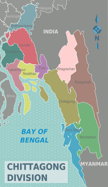
Chittagong Division is subdivided into eleven districts (zilas) and thence into 99 sub-districts (upazilas). The first six districts listed below comprise the north-western portion (37.6%) of the division, while the remaining five comprise the south-eastern portion (62.4%), the two portions being separated by the lower (or Bangladeshi) stretch of the Feni River; the upland districts of Khagrachhari, Rangamati and Bandarban together comprise that are a previously known as the Chittagong Hill Tracts. Before 1995, the four districts of Sylhet Division were also a part of Chittagong Division.
Brahmanbaria
Brahmanbaria district is in east-central Bangladesh, located in the Chittagong Division. It has an area of 1,927.11 square kilometers and a population of about 3.3 million. It is surrounded by Kishoreganj and Habiganj districts on the north, India on the east, Comilla district on the south, and Narsingdi, Narayanganj, and Kishoreganj districts on the west. It is geographically part of the Gangetic Plain and has a mostly flat and fertile terrain. It has many rivers, canals, lakes, and wetlands, such as the Titas, Meghna, Kalidaha, and Dhoronti. It also has some hilly areas in the northeast, such as the Lalmatis. It is known for its cultural heritage, natural beauty, and agricultural production.
Brahmanbaria is a traditional Titus-Vidhaut district of the central-eastern region of river-fed Bangladesh. There are several opinions regarding the naming of the Brahmanbaria district. It is heard that during the reign of the Sen dynasty, the lack of elite Brahmins in Brahmanbaria caused disturbances in worship. Because of this, King Lakshman Sen brought some Brahmin families from Adisur Kanyakunj to the region. Some Brahmin families built houses in Maulvi Para. Many believe that the district was named Brahmanbaria because of the location of the house of those Brahmins.
According to another theory, Shah Sufi Hazrat Kazi Mahmud Shah, an Islamic preacher from Delhi, ordered the said Brahmin families to leave the city, from which the name Brahmanbaria is believed to have originated.
The subdivision was established in 1860 at Brahmanbaria, bordering the state of Tripura in eastern India. Initially included in Tripura district. Comilla remained a subdivision of the district after the partition of India. It was established as a district on 15th February 1984.
Brahmanbaria is one of the leading towns in the country in terms of art, culture, education, and literature. Brahmanbaria district is the birthplace of many wise men, including the composer Ustad Alauddin Khan, Ustad Ayat Ali Khan, barrister A Rasul, Nawab Sir Syed Shamsul Huda, poet Advaita Malla Barman, poet Abdul Qadir, martyr Dhirendranath Dutta. Brahmanbaria district also contributes significantly to the national economy. Titus, Salda, and Meghna gas fields supply one-third of the country’s gas. Ashuganj Thermal Power Station is the country’s 2nd largest power generating station. Ashuganj Fertilizer Factory is one of the largest urea fertilizer factories in the country. Brahmanbaria district holds a special status on the map of this country as the bearer of industrial culture and a bright meeting place of religious and communal harmony irrespective of party affiliation.
Comilla District
Comilla District, officially known as Cumilla District, is a district of Bangladesh located about 100 kilometers southeast of Dhaka. It has a total area of 3,146.30 square kilometers and a population of 6,212,216, according to the 2022 census. Comilla is known for its historical and cultural heritage, such as the ancient Buddhist monastery of Shalban Vihara, the World War II cemetery, and the Nawab Faizunnesa House. Comilla is also famous for its local cuisine, especially the sweetmeat called Rosh malai. Comilla is part of the Chittagong Division and is divided into 17 upazilas and 8 municipalities. The district is bordered by Brahmanbaria and Narayanganj districts to the north, Noakhali and Feni districts to the south, Tripura of India to the east, and Munshiganj and Chandpur districts to the west.
Comilla has a tropical monsoon climate with hot and humid summers and mild winters. The average annual rainfall is about 2550 mm, and the average temperature ranges from 12°C to 35°C.
Comilla is an important commercial and educational hub in the region. It has several public and private universities, colleges, and schools. Some notable institutions are Comilla University, Comilla Medical College, Comilla Cadet College, and Ispahani Public School and College.
Comilla has a rich and diverse cultural heritage. It is home to many poets, writers, artists, and musicians. Some famous personalities from Comilla are Kazi Nazrul Islam, Abul Kalam Shamsuddin, Humayun Ahmed, Shamsur Rahman, and Runa Laila. Comilla also hosts various festivals and events, such as the Comilla Book Fair, the Comilla Mela, and the Comilla Folk Festival.
Chandpur District
Chandpur District is a district in the Chattogram Division of Bangladesh. It was formerly part of the Comilla District until 1984. It has a total area of 1,740.6 square kilometers and a population of 26,35,668, according to the 2022 census. It is divided into 8 upazilas and 7 municipalities.
Chandpur is situated at the confluence of the Padma and the Meghna rivers, which makes it a fertile and scenic region. Chandpur is known for its fish markets, especially the famous hilsa fish. Chandpur has a rich history and culture, with many historical sites, religious places, and festivals.
The Chandpur River Port is one of the busiest and oldest river ports in Bangladesh. It is also a gateway to the Sundarbans, the largest mangrove forest in the world. The Chandpur Central Park is a popular recreational spot for the locals and visitors. It has a lake, a fountain, a children’s playground, and a mini zoo.
The Chandpur War Cemetery is a memorial for the soldiers who died in the Second World War. It has 400 graves of British, Indian, and Australian troops. The Shitalakshya River Bridge is a modern and elegant bridge connecting Chandpur with Narayanganj. It is the longest pre-stressed concrete bridge in Bangladesh. The Chandpur Lighthouse is a historical landmark that was built in 1904. It is located on the bank of the Meghna River and offers a panoramic view of the surroundings.
Lakshmipur District
Lakshmipur district is a district of Bangladesh in the Chittagong division. It has an area of 1,440.39 square kilometers and a population of 1,937,948, according to the 2022 census. Chandpur, Bhola, Noakhali, Barisal, Munshiganj districts and the Meghna River border it. Lakshmipur is known for its fish markets, historical sites, and religious places. Some of the attractions of Lakshmipur are the Chandpur River Port, the Chandpur Central Park, the Chandpur War Cemetery, the Shitalakshya River Bridge, and the Chandpur Lighthouse. Lakshmipur has a literacy rate of 73.98% and a sex ratio of 1122 females per 1000 males. The main religion of Lakshmipur is Islam, followed by Hinduism. Lakshmipur has 4 municipalities, 5 upazilas, and 58 union parishads. The district was formerly part of Noakhali district until 1984.
Lakshmipur was formerly a military outpost during the Mughal and British periods. It was also a significant producer and exporter of salt until the 19th century. Lakshmipur witnessed several battles and movements during the Liberation War of Bangladesh in 1971. The freedom fighters attacked and killed many Pakistani soldiers in different places in Lakshmipur. It has many historical and religious sites, such as the Shalban Vihara, the Chandpur River Port, the Chandpur War Cemetery, and the Chandpur Lighthouse.
Noakhali District
Noakhali district is in southeastern Bangladesh, located in the Chittagong Division. It was established as a district in 1821 and officially named Noakhali in 1868. It has an area of 4,202.70 square kilometers and a population of 3,625,252, according to the 2022 census. The district is about 5 km from Dhaka’s cap and ital and 5 km from the Chittagong divisional headquarters. Chittagong and Feni districts are on the east, Comilla districts are on the north, Lakshmipur and Bhola districts are on the west, and the Bay of Bengal is on the south.
Comilla, Feni, Chittagong, Bhola, Lakshmipur district, the Meghna estuary, and the Bay of Bengal border Noakhali. Noakhali is known for its fish markets, especially the hilsa fish, and its historical and cultural sites, such as the Shalban Vihara, the Chandpur River Port, the Chandpur War Cemetery, and the Chandpur Lighthouse. Noakhali has 9 upazilas and 8 municipalities. Noakhali was formerly part of the ancient kingdom of Bhulua and witnessed several battles and movements during the Liberation War of Bangladesh in 1971. Noakhali has a literacy rate of 59.6% and a sex ratio of 1008 females per 1000 males.
The ancient name of the Noakhali district was Bhulua. The original name of Noakhali Sadar Police Station is Sudharam. According to historians, the northeast of Vulua flooded the river Dakatia, once flowing from the hills of Tripura, and the cropland was severely damaged. To get rid of this situation, a vast canal was excavated in the 5th, which flows from the Dakatia River to Ramganj, Sonimuri, and Choumuhani to the Meghna and Feni Rivers. This vast new canal was called Noakhali’s regional canal, which caused the region to become known as Noakhali at one time.
Feni District
Feni district is in the southeast of Bangladesh, under the Chittagong Division. It has a total area of 928.34 km2 and a population of about 1.6 million. It is bordered by Comilla District and Tripura state of India in the north, Chittagong District and Bay of Bengal in the south, Chittagong District and Tripura state in the east and Noakhali District in the west. Feni district has six sub-districts (upazilas), five municipalities and 43 unions. The district’s administrative headquarters is in Feni City, the largest city in the district. Feni district has a rich history and culture and is known for its natural beauty, agricultural products, and historical sites.
The region is named after the Feni River. When the Amirgaon police station of the Mughal period faced river erosion between 12-5, it was transferred to Khayyara near the Feni River Ghat. The police station was known as Feni thana (near Feni River) in the paper.
Khagrachhari District
Khagrachhari district is in the southeast of Bangladesh, under the Chittagong Division. It is part of the Chittagong Hill Tracts region, home to various indigenous groups with their languages and cultures. Khagrachhari district has an area of about 2,749 km2 and a population of about 714,000. The district is known for its natural beauty, historical sites, and tourist attractions. It has nine sub-districts (upazilas), three municipalities and 38 unions.
History reveals that from the sixth century AD to the fourteenth century AD, the area has been ruled by Tripura, sometimes or the Arakan kingdoms. In the meantime, the Tripura kings ruled the Chittagong Hill Tracts (including Khagrachari) and Chittagong for three years from 1 to 5 AD. Then, the Arcan kings ruled the area for 25 years, from 7 AD to 125 AD, but the Tripura kings again dominated the area for 12 years (from 12 AD).
History is known that the Tripura kings from the tenth century to the fifteenth century took over the area eight (nine) times, and the sultans of Gaur (Muslim) occupied the area six (six) times. Finally, in 12 AD, the Muslim ruler Sultan Fakruddin Mubarak Shah took control of the region, including Chittagong, from the power of the Tripura king. In the continuation of Muslim rule, the occupation of the mosque of Bengal by the East India Company in 7 AD was the British government from Nawab Mir Qasim’s Calat in 7 AD during the reign of Nawab Mir Qasim Ali Khan.
Then, on February 7, the war of Independent Tripura Maharaja with the British Government took place. An agreement was signed between the two in the wake of the defeat of the Tripura king in the war. According to Article 1 of the Agreement, “Chittagong Hill Revenue and Administrative Executive powers will be vested in the hands of the English government”, the Chittagong Hill Tracts has been separated from the state of Tripura Maharaj and Tripura state.
The British government was finalized in Chittagong at the hands of Nawab Mir Qasim of Bengal on October 7, and the Chittagong Hill Tracts (part particular) were from the Kabbal of the Tripura Maharaja in 7 AD. Then, according to notification No.12 of June 7 and 8, Chittagong Hill Tracts were separated from Chittagong and declared an independent district. Later, the English government divided the Chittagong Hill Tracts into three circles, Mong, Chakma and Bomang, on September 1 to facilitate the collection of revenue. Moreover, the British government introduced the “Chittagong Hill Tracts Frontier Police Act” in 7 AD and formed a separate police force with local indigenous people.
Rangamati District
Rangamati Hill District of Natural Beauty is located under the Chittagong Division. It has an area of about 6,116.13 km2 and a population of about 620,214. Rangamati district has ten sub-districts (upazilas), two municipalities and 50 unions. The district is known for its natural beauty, historical sites, and tourist attractions. Tripura, Mizoram to the north of Rangamati, Bandarban to the south, Mizoram to the east, Chittagong, and Khagrachari to the west. This district is the largest in the country. The only rickshaw city in the country, the lake-surrounded tourist city area. In this district, four people, including Chakma, Marma, Tanchangya, Tripura, Morang, Bomb, Khumi, Khayang, Chak, Pangkhwa, Lusai, Sujasutal, Rakhine are all in place.
Rangamati, Khagrachari and Bandarban: Carpas Mahal was the previous name of the Chittagong Hill Tracts. Bandarban was created in Bandarban and Khagrachari from the Chittagong Hill Tracts district. Separate districts were made in the 5th. In the traditional revenue collection system, the Chakma Circle Chief is in the Rangamati Hill District. The King of Chakma is the Circle Chief of the Regional Chakma.
Bandarban district
Bandarban district of Natural Beauty is located under the Chittagong Division. It has an area of about 6,116.13 km2 and a population of about 620,214. Rangamati district has ten sub-districts (upazilas), two municipalities and 50 unions. The district is known for its natural beauty, historical sites, and tourist attractions.
There is a legend on the naming of Bandarban district. The prevailing form of the area’s residents is that many monkeys live there at once. And these monkeys used to eat salt on the hills at the city’s entrance. Once upon a time, due to the continuous rain, the monkey group could not go to the mountains as the monkey group could not go to the hill. The people of this town see this scene of monkey crossing. From this time onwards, the place became known as “mauchi rhyme”. That is, in the Marma language, Matah means monkey and shit money dam. Over time, the name of this area became Bandarban in the general Bengali accent. The name of this district has become permanent in government documents as Bandarban. However, Bandarban’s name is “Rad Kochi Mro” in Marma.
During the British rule, the Chittagong Hill Tracts was declared a district in the 5th. At that time, Bandarban was under the Chittagong Hill Tracts district. Captain Magrett was the first superintendent of the Chittagong Hill Tracts district. The activities of the Chittagong Hill Tracts district superintendent were further expanded in the 5th, and the post was named the Deputy Commissioner in the 5th. The first deputy commissioner of the Chittagong Hill Tracts district was T. H. Luin. According to the Chittagong Hill Tracts Regulation, Chittagong Hill Tracts were divided into three circles-Chakma Circle, Mong Circle, and Bomang Circle. A circle was employed for each circle. Bandarban was then under the Bomang Circle. The leading name of this district is Bomang Thong because of the inclusion of the Bomang Circle.
Bandarban district started administrative activities as a subdivision in the 5th. It was an organisational unit of the Rangamati district. On April 7, the then Lama subdivision debuted as the Bandarban Hill District with seven upazilas, including geographical and administrative borders.
Chittagong District
Chittagong District, also known as Chattogram District, is a district in the south-eastern region of Bangladesh. It is part of the Chittagong Division, the country’s largest administrative division. The district has a total area of 5,282.92 km2 and a population of 9,169,464, according to the 2022 census. The district is home to the port city of Chittagong, the second-largest city in Bangladesh and a central hub for trade, commerce, and industry. The district has many natural and historical attractions, such as the Mahamaya Lake, the Chandranath Temple, the Anderkilla Shahi Jame Mosque, and the Sitakunda Eco Park. The district is divided into 15 upazilas, 15 municipalities and 31 thanas for administrative purposes.
Due to mountains, sea, valleys, and forests, the geographical picture of Chittagong is no more advantageous. Chittagong district is bordered by Feni district and the Indian state of Tripura to the north, Cox’s Bazar district to the south, Bandarban, Rangamati, and Khagrachari districts to the east, and Noakhali district and the Bay of Bengal to the west. Besides, the island is part of Sandwip Chittagong. Historically, the area has been under the influence of various regional powers, including the Arakanese, the Mughals, the British, and the Portuguese, each leaving their mark on the history and development of the region.
Cox’s Bazar District
Cox’s Bazar District is a district in the Chittagong Division of Bangladesh, named after the town of Cox’s Bazar. It is famous for its long natural sea beach, the longest in the world. The district has an area of 2,491.86 km2 and a population of 2,823,265, according to the 2022 census. The district has many tourist attractions, including the Fasiakhali Wildlife Sanctuary, the Adinath Temple, the Himchori Waterfall, and the Rangkut Banasram Monastery. The district is also home to the Rohingya refugees, who fled from Myanmar due to persecution. The district is divided into nine upazilas, four municipalities and nine thanas for administrative purposes.
There is a little history behind naming Cox’s Bazar. Its ancient name was Palangki. It was once known as Panoa. The word Panoa means ‘yellow flower’. In the past, the areas around Cox’s Bazar shone with this yellow flower. It is located 159 km south of Chittagong. Modern Cox’s Bazar is named after the famous British naval officer Captain Hiram Cox (d. 1798). who was an army officer in British India.
Some frequently asked questions about Chittagong Division are:
What are the main attractions of the Chittagong Division?
Chittagong Division is home to many natural and cultural attractions, such as Cox’s Bazar, the longest natural sea beach in the world; St. Martin’s Island, the only coral island in Bangladesh; the Chittagong Hill Tracts, a scenic region of hills, forests and indigenous communities; and the port city of Chittagong, the second-largest city and the commercial capital of Bangladesh.
How many districts are there in the Chittagong Division?
Chittagong Division is subdivided into eleven districts: Bandarban, Brahmanbaria, Chandpur, Chittagong, Comilla, Cox’s Bazar, Feni, Khagrachhari, Lakshmipur, Noakhali and Rangamati.
How can I travel to Chittagong Division?
Chittagong Division is well-connected by road, rail, air and water transport. You can reach Chittagong Division by bus or train from Dhaka, the capital city of Bangladesh, or by domestic or international flights to Shah Amanat International Airport in Chittagong. You can also take a ferry or a cruise from Dhaka or other coastal cities to Chittagong or Cox’s Bazar.
What are the main crops and industries of the Chittagong Division?
Chittagong Division is known for its agricultural and industrial production. The main crops grown in the Chittagong Division are rice, wheat, maize, potato, sugarcane, jute, tea, tobacco and fruits. The primary industries of the Chittagong Division are shipbuilding, steel, textiles, garments, leather, pharmaceuticals, cement, ceramics, paper, fertilizer and seafood.
Sources : Census figures for 1991, 2001 and 2011 are from Bangladesh Bureau of Statistics, Population Census Wing. The 2011 Census figures are based on preliminary results.


I got what you intend,bookmarked, very decent website.
I am incessantly thought about this, thanks for posting.
This site definitely has all of the information I needed about this subject
My website: порно азиаток
Thank you ever so for you blog. Really looking forward to read more.
My website: gaypornoxxl.com
Major thanks for the article post. Much thanks again.
My website: порно китайцы